
Unveiling Hidden Empires: Modern Archaeology’s Astonishing Discoveries of Ancient Civilizations
Imagine entire cities, vast networks of roads, and sophisticated societies swallowed by time, hidden beneath jungles, deserts, or even our very feet. Modern archaeology isn’t just about dusty digs and ancient pots anymore; it’s a high-tech treasure hunt, leveraging cutting-edge science to unearth these lost worlds. From laser-scanning the depths of Amazonian rainforests to peering beneath the sands of the Sahara, today’s archaeologists are rewriting history, revealing the spectacular scale and complexity of ancient civilizations we barely knew existed. Prepare to journey into the past, as we explore how innovative techniques are bringing hidden empires back into the light.

The Shifting Sands of History: Why Empires Remain Hidden
For millennia, human civilizations have risen, flourished, and, for various reasons, faded from collective memory. Natural disasters like earthquakes, volcanic eruptions, or tsunamis can bury entire cities in an instant. Environmental changes, such as desertification or rising sea levels, can render once-fertile lands uninhabitable, forcing populations to abandon their homes and leaving their structures to the elements. Political upheavals, invasions, or societal collapses can lead to the deliberate destruction or gradual neglect of urban centers, allowing nature to reclaim them.
Beyond these cataclysmic events, sheer remoteness and the passage of time also play a significant role. Dense jungles can quickly engulf monumental architecture, turning bustling metropolises into indistinguishable mounds of earth. Vast deserts can swallow entire settlements, leaving no trace on the surface. And sometimes, even when ruins are visible, their true significance or the full extent of the civilization they represent remains unknown, misinterpreted, or simply unappreciated for centuries. This is where modern archaeology steps in, armed with tools and techniques that allow us to see through the camouflage of time and nature.
Tools of the Trade: How Modern Archaeology Finds the Lost
The image of an archaeologist painstakingly brushing away dirt with a small tool is still accurate, but it’s only one piece of a much larger, technologically advanced puzzle. Modern archaeology employs a remarkable array of techniques, many borrowed from aerospace, geology, and medicine, to locate, map, and understand ancient sites without always needing to put a shovel in the ground. These methods are revolutionizing our ability to find hidden empires.
Remote Sensing: Eyes in the Sky and Underground
Perhaps the most transformative advancements come from remote sensing, allowing archaeologists to survey vast areas quickly and non-invasively.
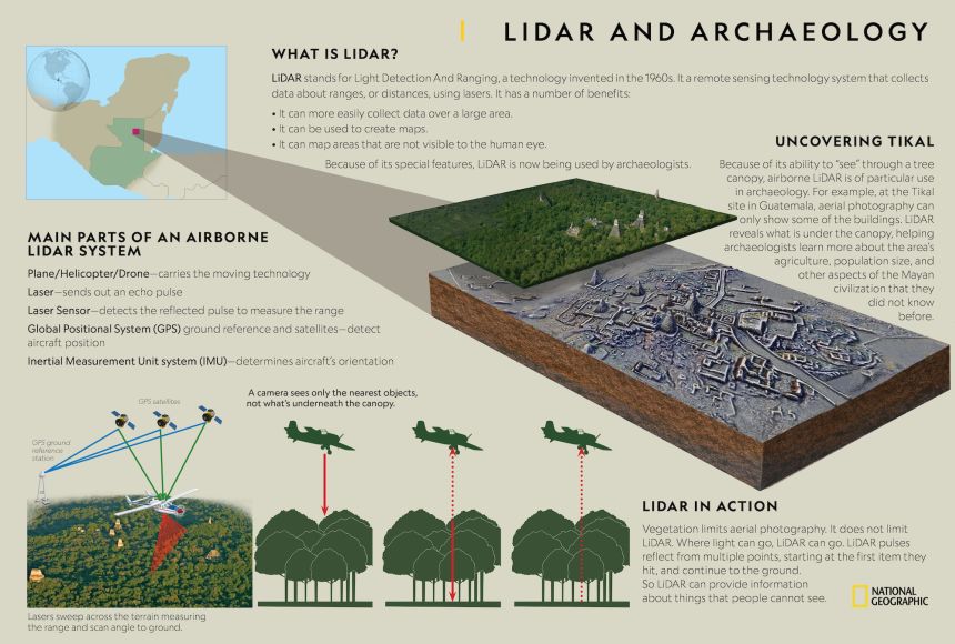
- Lidar (Light Detection and Ranging): This revolutionary technology uses pulsed lasers fired from an aircraft to map the ground surface in incredible detail. Lidar can penetrate dense forest canopies, effectively stripping away vegetation in the resulting data, revealing ancient roads, building foundations, terraces, and agricultural fields that have been hidden for centuries. It’s like giving archaeologists x-ray vision for entire landscapes, transforming our understanding of civilizations in places like the Amazon and the Maya lowlands.
- Ground-Penetrating Radar (GPR): Unlike Lidar, GPR works from the ground, sending radar pulses into the earth to detect subsurface features. As the radar waves encounter different materials or voids, they reflect back, creating a detailed profile of what lies beneath. GPR is invaluable for mapping buried walls, tombs, foundations, and even ancient utility systems without disturbing the soil.
- Satellite Imagery and Aerial Photography: While not new, the sheer availability and resolution of satellite imagery (including publicly accessible tools like Google Earth) have made it an indispensable first step for identifying potential archaeological sites. Anomalies in vegetation, subtle changes in terrain, or geometric patterns that hint at human construction can be spotted from space, guiding ground teams to promising areas. Drones equipped with high-resolution cameras now provide even more detailed aerial views, capturing changes over time and creating 3D models of sites.
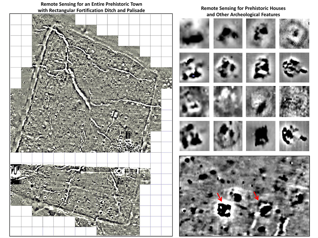
- Magnetometry: This technique measures variations in the Earth’s magnetic field. Buried features like kilns, hearths, ditches filled with refuse, or even stone walls can create magnetic anomalies that are detectable from the surface. These magnetic surveys can quickly map out the layout of an entire buried settlement.
- Electrical Resistivity: Similar to magnetometry, electrical resistivity measures the electrical resistance of the soil. Stone walls, compacted surfaces, or buried features like pathways will have different electrical properties than undisturbed soil, allowing archaeologists to map them out.
- Photogrammetry and 3D Modeling: Once a site is excavated or even just surveyed, photogrammetry (stitching together hundreds of photos) and 3D laser scanning create incredibly accurate digital models. These models preserve the site digitally, allow for virtual exploration and analysis, and can even reconstruct damaged structures.
- DNA Analysis (Archaeo-genetics): Recovering ancient DNA from human remains, animal bones, or even soil samples can reveal migration patterns, dietary habits, disease prevalence, and kinship structures within ancient populations.
- Archaeo-botany and Zooarchaeology: The study of ancient plant remains (seeds, pollen) and animal bones provides critical insights into diet, agriculture, environmental conditions, and human-animal interactions.
- Historical Linguistics and Oral Traditions: In many cultures, spoken language and storytelling preserve echoes of the past. Collaborating with linguists and local communities can provide crucial clues about lost places, forgotten events, and the identities of ancient peoples, guiding archaeological investigations.
- The Role of Lidar in Modern Archaeology
- Ancient Engineering Marvels: Water Management in Early Civilizations
- Understanding Pre-Columbian Societies in the Americas
- National Geographic Archaeology (Opens in new window)
- Smithsonian Magazine Archaeology (Opens in new window)
- Image 1 (Lidar Scan Example): “Vibrant Lidar scan overlaying a dense jungle, revealing ancient Mayan city structures and road networks hidden beneath the trees.”
- Image 2 (Caral Pyramids): “Panoramic view of the ancient Caral pyramids in Peru, showing large stone platforms and ceremonial plazas under a clear sky.”
- Image 3 (Angkor Wat Aerial): “Aerial view of Angkor Wat temple complex, with surrounding Lidar-revealed urban sprawl and waterways extending into the jungle.”

Non-Invasive Techniques: Preserving While Discovering
Many modern methods prioritize non-invasive investigation, allowing researchers to gather data without damaging fragile sites.

Interdisciplinary Approaches: Beyond the Shovel
Modern archaeology is inherently interdisciplinary, drawing on a vast range of scientific fields to paint a richer picture of the past.
Unveiling Giants: Notable Discoveries of Hidden Empires
Thanks to these incredible advancements, the last few decades have seen an explosion of discoveries, revealing entire civilizations whose scale, complexity, or very existence were previously unknown or vastly underestimated.
The Lost City of Teyuna (Ciudad Perdida), Colombia: A Tayrona Masterpiece
Deep within the Sierra Nevada de Santa Marta mountains of Colombia lies Teyuna, better known today as Ciudad Perdida (“Lost City”). This monumental settlement of the ancient Tayrona people was built around 800 CE, predating Machu Picchu by several centuries. Unlike many sites discovered by archaeologists, Teyuna was stumbled upon by local treasure hunters in 1972, who then led official expeditions to the site.
What they found was astonishing: a sprawling city of circular stone terraces carved into the steep mountainside, interconnected by a complex network of stone paths and staircases – some 1,200 steps in total. The Tayrona were skilled engineers, constructing sophisticated drainage systems and platforms for dwellings and ceremonial centers. Lidar surveys have since revealed that Teyuna was just one part of a much larger, interconnected network of Tayrona settlements, indicating a highly organized and populous society. The Tayrona people, descendants of whom still live in the region today, were master gold workers and farmers, creating a thriving civilization in a challenging mountainous environment, a true hidden empire until very recently.
Caral-Supe, Peru: The Oldest Civilization in the Americas
For a long time, the Olmec civilization of Mesoamerica was considered the earliest complex society in the Americas. Then, in the late 1990s, archaeological work at Caral in the Supe Valley of Peru, building on earlier investigations, revealed something truly groundbreaking. Radiocarbon dating showed that Caral, with its monumental stone pyramids and ceremonial plazas, was constructed as early as 2600 BCE – making it contemporary with the pyramids of Egypt and predating the Olmec by over a millennium.
Caral is the heart of the Caral-Supe civilization, a vast network of at least 20 major urban centers spread across three river valleys. What makes Caral-Supe particularly intriguing is its apparent lack of defensive structures and evidence of warfare. Instead, it seems to have been a peaceful, highly organized society focused on trade, music (flutes made of condor and pelican bones have been found), and spiritual practices. Their monumental architecture, advanced urban planning, and sophisticated social structure, all revealed through careful excavation and dating, represent a hidden empire that completely rewrote the timeline of civilization in the Western Hemisphere.
Angkor’s Vast Network, Cambodia: Lidar Reveals a Megacity
The temples of Angkor Wat in Cambodia are world-famous, a testament to the grandeur of the Khmer Empire. For decades, archaeologists marveled at the scale of these stone structures, but the true extent of the empire’s capital city remained largely obscured by the dense jungle. Conventional ground surveys struggled to penetrate the thick vegetation, leading to an underestimation of Angkor’s urban sprawl.
Then came Lidar. In 2012 and again in 2015, extensive Lidar surveys were conducted over the Angkor region. The results were nothing short of revolutionary. Beneath the jungle canopy, Lidar revealed an astonishingly vast and complex urban landscape, far larger than any pre-industrial city previously known. It uncovered a sprawling network of ancient roads, canals, reservoirs, agricultural fields, and hundreds of previously unknown temples and residential areas. This wasn’t just a collection of temples; it was a low-density, highly organized megacity, supported by an incredibly sophisticated hydraulic engineering system that managed water for agriculture and urban needs across an area of over 1,000 square kilometers. Lidar didn’t just find new sites; it fundamentally changed our understanding of the Khmer Empire’s population, infrastructure, and urban planning.
The Garamantes, Sahara Desert: Masters of the Ancient Oasis
In the seemingly barren Sahara Desert of what is now Libya, an advanced civilization once flourished: the Garamantes. For centuries, their existence was hinted at in ancient Roman and Greek texts, often dismissed as semi-mythical desert raiders. Modern archaeology, particularly through aerial surveys and later ground excavations, has brought this hidden empire vividly to life.
Beginning in the 1960s and intensifying in recent decades, archaeologists using satellite imagery, aerial photography, and eventually ground-penetrating radar, began to map an extensive network of ancient settlements and, crucially, an unparalleled system of underground irrigation channels known as foggara. These channels, often stretching for miles, tapped into ancient aquifers beneath the desert, allowing the Garamantes to cultivate vast areas of land and sustain a thriving urban culture in an incredibly hostile environment. They built impressive fortified towns, castles, and elaborate tombs, demonstrating a sophisticated social structure and considerable wealth derived from trans-Saharan trade. The Garamantes were not just desert nomads; they were master engineers and agriculturalists who built a powerful and enduring empire in one of the world’s harshest landscapes, a true testament to human ingenuity.
Liangzhu Culture, China: A Neolithic Water City
The history of Chinese civilization is often traced back to the Shang and Zhou dynasties. However, modern archaeological discoveries continue to push back these timelines, revealing earlier, highly sophisticated cultures. One of the most remarkable is the Liangzhu culture, which flourished in the Yangtze River Delta between 3300 and 2300 BCE. While known for its exquisite jade artifacts, the true scale and nature of Liangzhu as a major civilization were only fully recognized in the 21st century.
Recent excavations and extensive surveys, including the use of remote sensing, have uncovered a massive ancient city at Liangzhu, surrounded by an elaborate system of dikes, dams, and artificial reservoirs. This isn’t just a city; it’s a monumental hydraulic engineering project, designed to control water for flood prevention, irrigation, and transportation. The city itself, with its inner and outer walls, ceremonial platforms, and extensive burial sites rich in jade artifacts (including the iconic cong and bi discs), reveals a highly stratified society with a powerful ruling elite and a sophisticated understanding of water management. Liangzhu represents an early state-level society with monumental architecture and advanced technology, a hidden empire that fundamentally reshapes our understanding of early Chinese civilization.
The Maya Lowlands: A Megalopolis Beneath the Jungle
The Maya civilization of Mesoamerica has captivated imaginations for centuries with its towering pyramids and intricate calendar system. Yet, like Angkor, the full extent of its urban development has been persistently underestimated due to the dense jungle canopy that swallowed countless settlements after its decline. Traditional archaeological methods, limited by visibility and terrain, could only scratch the surface of Maya urbanism.
The advent of Lidar has, once again, been a game-changer. Sweeping surveys across regions like northern Guatemala have revealed an astonishing reality: the Maya lowlands were not just dotted with isolated city-states, but comprised an interconnected, densely populated megalopolis. Lidar has uncovered tens of thousands of previously unknown structures, including houses, defensive walls, elevated causeways connecting cities, and extensive agricultural modifications like terraces and irrigation canals. It showed that the Maya had a far greater population than previously estimated and developed incredibly sophisticated, large-scale infrastructure to support it. This redefines our understanding of Maya society, revealing a hidden empire of interconnected urbanism that was far more extensive and complex than we ever imagined.
Beyond the Dig Site: What These Discoveries Teach Us
The unveiling of these hidden empires is more than just an academic exercise; it has profound implications for our understanding of human history, adaptability, and the trajectory of civilization itself.
Firstly, these discoveries constantly rewrite our history books. They challenge long-held assumptions about the origins of urbanism, the development of complex societies, and the spread of technology. Caral-Supe pushes back the timeline of monumental architecture in the Americas by thousands of years, while Liangzhu reveals advanced hydraulic engineering in Neolithic China. These findings demonstrate that human innovation and societal complexity emerged independently in diverse parts of the world, often much earlier than previously thought.
Secondly, they highlight the incredible adaptability and resilience of human societies. Whether building vast cities in challenging mountain environments like the Tayrona, mastering desert agriculture like the Garamantes, or managing vast water systems in tropical lowlands like the Khmer and Maya, ancient peoples consistently found ingenious solutions to environmental challenges. Their successes and failures offer valuable lessons for our own contemporary struggles with climate change and resource management.
Finally, these discoveries underscore the ongoing nature of exploration and the vastness of what remains unknown. Even in areas thought to be thoroughly surveyed, new technologies continue to reveal hidden layers of human activity. Every new finding opens up new questions, prompting further research and deeper insights into the human story.
The Future of Unveiling: More Empires Await
The journey to uncover hidden empires is far from over. With each passing year, archaeological techniques become more refined, more powerful, and more accessible. Satellite imagery continues to improve, Lidar is becoming even more precise, and artificial intelligence is beginning to assist in analyzing vast datasets, identifying patterns that human eyes might miss.
There are still vast, unexplored regions of the world – the untouched depths of the Amazon rainforest, the unexplored expanses of the Siberian taiga, the submerged coastlines of ancient seas. As technology advances and interdisciplinary collaboration deepens, we are poised to discover even more astonishing hidden empires, further enriching our understanding of our shared past and the incredible legacy of human ingenuity.
The thrill of discovery, the quiet whisper of a forgotten civilization emerging from the earth, remains a powerful motivator for archaeologists and history enthusiasts alike. It reminds us that our world holds countless stories yet to be told, waiting patiently for the right tools and the right minds to bring them back to life.
Explore hidden empires with our interactive timeline and embark on your own journey through ancient history.
*
Internal Link Opportunities:
External Link Opportunities:
Image Alt Text Suggestions: