
Unveiling Hidden Empires: Modern Archaeology’s Revelations of Lost Civilizations
Imagine ancient cities swallowed by dense jungle, forgotten kingdoms buried beneath shifting sands, or vast urban networks hidden by millennia of agricultural growth. For centuries, many of these “hidden empires” remained the stuff of legend or pure speculation. However, thanks to the revolutionary tools and interdisciplinary approaches of modern archaeology, we are now continually uncovering previously unknown or poorly understood ancient civilizations, radically reshaping our understanding of human history and cultural development. This isn’t just about finding old pots; it’s about rewriting the story of humanity, revealing the incredible ingenuity, complexity, and diversity of societies that once thrived across our planet.

What Makes an Empire “Hidden”?
When we talk about “hidden empires,” we’re not necessarily discussing civilizations that vanished without a trace, but rather those whose scale, influence, or very existence was either unknown, underestimated, or misinterpreted by conventional historical narratives. Several factors contribute to this obscurity, making their discovery a monumental achievement for modern archaeology.
Sometimes, nature itself is the ultimate concealer. Dense rainforests, like those in Mesoamerica or the Amazon, can rapidly reclaim vast settlements, covering monumental structures with layers of vegetation and soil. Shifting desert sands can bury entire cities, preserving them while simultaneously erasing them from the visible landscape. In other cases, a lack of written records or the destruction of historical documents meant that once-thriving cultures simply faded from collective memory, leaving only enigmatic mounds or faint earthworks that were easily dismissed by earlier generations of researchers. Remote locations, difficult to access even today, also played a role, shielding these sites from casual discovery. Ultimately, many empires remained hidden simply because the technology and methodologies to detect their subtle imprints on the landscape hadn’t yet been invented.

The Dawn of a New Era: How Modern Archaeology Transformed the Search
For generations, archaeology was largely defined by the trowel, the brush, and the painstaking excavation of individual sites. While these methods remain crucial, the last few decades have seen a dramatic evolution, transforming archaeology into a high-tech, interdisciplinary science capable of revealing entire lost landscapes from above and below ground.
Beyond the Trowel: The Rise of Remote Sensing
The biggest game-changer in the search for hidden empires has undoubtedly been remote sensing technology. These tools allow archaeologists to “see” through vegetation, soil, and even water, detecting anomalies that suggest human activity without ever digging a single trench.
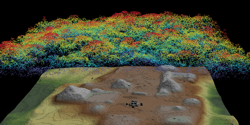
Lidar (Light Detection and Ranging) is arguably the most celebrated of these technologies. Mounted on aircraft or drones, Lidar systems fire millions of laser pulses per second down to the ground. These pulses penetrate gaps in the tree canopy, reflecting back to the sensor. By filtering out the vegetation returns, researchers can generate incredibly detailed 3D maps of the bare earth, revealing subtle contours, terraces, roads, and structures that have been hidden for centuries. It’s like peeling back the jungle itself to expose an ancient city grid.
Satellite Imagery and Aerial Photography have also become indispensable. While not as penetrating as Lidar, high-resolution satellite images (including those publicly available through platforms like Google Earth) allow archaeologists to spot faint crop marks, subtle changes in soil color, or geometric patterns that hint at buried walls or ancient field systems. Specialized aerial photography, sometimes using infrared or multispectral cameras, can highlight features invisible to the naked eye.
Ground-Penetrating Radar (GPR) uses radio waves to detect objects and changes in soil composition beneath the surface. By sending pulses into the ground and measuring the reflections, GPR can create cross-sectional images, revealing buried walls, foundations, tombs, and even ancient ditches without disturbing the soil. This is particularly useful for mapping features within known sites or in areas with less dense vegetation.
Magnetometry and Electrical Resistivity are other geophysical survey techniques that detect variations in the Earth’s magnetic field or electrical resistance caused by buried archaeological features. For instance, a fired clay hearth or a ditch filled with organic material will have a different magnetic signature or electrical conductivity than undisturbed soil, allowing archaeologists to map subsurface structures over large areas.

Data Science and AI: Pattern Recognition in the Past
It’s not just about collecting data; it’s about making sense of it. Modern archaeology now leverages data science and artificial intelligence (AI) to process the enormous datasets generated by remote sensing. AI algorithms can be trained to recognize patterns indicative of ancient settlements, sift through vast amounts of imagery, and even predict the most likely locations for new discoveries based on environmental factors and known archaeological precedents. This dramatically speeds up the identification process and reduces the need for costly and time-consuming ground surveys in unproductive areas.

Interdisciplinary Approaches: A Holistic View
Beyond technology, modern archaeology thrives on collaboration. Archaeologists now routinely work with botanists (archaeobotany) to understand ancient diets and environments, zoologists (zooarchaeology) to identify animal remains, geologists (geochronology) to date soil layers, and geneticists (aDNA analysis) to study ancient human populations and migrations. Collaboration with indigenous communities is also becoming increasingly vital, incorporating local knowledge, oral histories, and traditional land management practices that can offer invaluable clues to hidden sites and their significance. This holistic approach paints a much richer and more accurate picture of ancient life.
Case Studies: Unearthing Empires from the Sands and Jungles
The impact of modern archaeology’s innovations is best illustrated by the incredible “hidden empires” that have recently come to light, challenging long-held assumptions about human history.
The Maya Lowlands: A Network Far Beyond Expectations (Lidar’s Triumph)
For decades, archaeologists believed that ancient Maya cities, though impressive, were relatively isolated urban centers scattered across the dense jungles of Mesoamerica. Traditional excavation methods, slow and arduous in the thick vegetation, only reinforced this perception. Then came Lidar.
In the Mirador Basin of Guatemala, Lidar surveys have revealed an astonishingly vast and interconnected network of Maya cities, towns, and villages, many dating back to the Preclassic period (c. 1000 BCE – 250 CE). This includes the massive city of El Mirador itself, with pyramids taller than any known in Egypt, connected to other major centers by a sophisticated system of elevated causeways stretching for miles. Similarly, Lidar analysis around Tikal has shown its true urban sprawl, revealing thousands of previously unknown structures, extensive agricultural terraces, and defensive fortifications, suggesting a population density and level of organization far beyond previous estimates.
Even more recently, Lidar in Cambodia has unveiled Mahendraparvata, a sophisticated city of the Khmer Empire hidden beneath the Phnom Kulen mountain, predating Angkor Wat by several centuries. These discoveries demonstrate that the Maya and Khmer civilizations were not just collections of city-states, but highly integrated, complex societies with extensive infrastructure and populations that rivaled many European cities of later eras.
The Lost Cities of the Amazon: Complex Societies in the “Empty” Forest
The Amazon rainforest has long been perceived by many as a “pristine wilderness” inhabited only by small, nomadic groups before European contact. However, modern archaeology is systematically dismantling this myth, revealing evidence of vast, complex societies that engineered their landscapes on an epic scale.
In the Bolivian Amazon, Lidar and satellite imagery have helped identify the remains of the Casarabe culture, a sophisticated society that built elaborate ceremonial centers, vast earthworks, and an intricate network of canals and reservoirs between 500 and 1400 CE. These discoveries include monumental platforms, plazas, and defensive structures, transforming our understanding of pre-Columbian Amazonian urbanism.
Even more astounding are the recent Lidar revelations in Ecuador’s Upano Valley. Here, archaeologists have uncovered an extensive network of ancient cities, towns, and hamlets connected by roads and surrounded by vast agricultural fields and terraced hillsides, dating back at least 2,500 years. These settlements were far more numerous and densely populated than anything previously imagined for the region, showcasing a highly organized society that thrived in the Amazonian environment for over a millennium. These findings challenge deeply ingrained assumptions about the Amazon’s human history and demonstrate the incredible adaptability and engineering prowess of its ancient inhabitants.
The Indus Valley Civilization: Re-evaluating Urban Giants
The Indus Valley Civilization (also known as the Harappan Civilization), flourishing from around 2500 to 1900 BCE across parts of modern-day Pakistan and India, was one of the world’s three early cradle civilizations, alongside ancient Egypt and Mesopotamia. While its major cities like Mohenjo-Daro and Harappa have been known for a century, modern archaeological techniques are continually revealing new dimensions of this enigmatic empire.
New discoveries, such as the massive city of Rakhigarhi in India, are helping to clarify the sheer scale and sophistication of this civilization. Using techniques like GPR and detailed mapping, archaeologists have revealed a sprawling urban center, complete with advanced drainage systems, grid-planned streets, and evidence of specialized craft production. Similarly, sites like Dholavira, with its unique water management system designed to capture monsoon rains, are being re-examined with new technologies to understand their engineering marvels and adaptation to a semi-arid environment. These ongoing discoveries emphasize the Indus Valley’s incredible urban planning, sophisticated trade networks, and still-undeciphered script, continually pushing the boundaries of our knowledge about this ancient powerhouse.
The Hittites and Beyond: Anatolia’s Bronze Age Powerhouses
While the Hittite Empire (c. 1600–1178 BCE) in Anatolia (modern-day Turkey) is well-known from ancient Egyptian and Mesopotamian texts, modern archaeology continues to deepen our understanding of its true extent and influence. Excavations at sites like Hattusa, the Hittite capital, continually reveal new layers of its monumental architecture, intricate cuneiform archives, and advanced defensive systems.
Beyond the capital, the application of systematic surveys, aerial photography, and geophysical techniques has helped map out the vast network of Hittite vassal states, trade routes, and military outposts across Anatolia and into northern Syria. For instance, the excavation and mapping of Karkemish, a strategically vital Hittite city on the Euphrates, has revealed its complex urban layout and its role as a major cultural and political center after the collapse of the main empire. These modern approaches clarify the Hittites’ role as a major Bronze Age superpower, capable of challenging Egypt and wielding immense regional influence through sophisticated diplomacy and military might.
The Scythian Gold and Siberian Ice Maidens: Nomadic Empires of the Steppe
The Scythians were a confederation of equestrian nomadic peoples who dominated the Eurasian Steppe from the 9th to the 1st century BCE. While their “gold” artifacts have long captivated the world, modern archaeology, particularly with advanced dating techniques and genetic analysis, is providing unprecedented insights into their vast territorial reach, social structure, and interactions with settled civilizations.
Archaeologists have been systematically investigating thousands of burial mounds (kurgans) across Siberia, Kazakhstan, and Ukraine. The use of ground-penetrating radar and precise excavation techniques has allowed for the careful recovery of incredibly well-preserved organic materials from permafrost-sealed kurgans, such as those at Ukok Plateau, home to the famous “Siberian Ice Maiden.” Analysis of these remains, including ancient DNA, helps trace their origins, migration patterns, and genetic relationships, revealing a complex web of nomadic groups rather than a single monolithic empire. The sheer wealth of gold, intricate textiles, and foreign artifacts found in these kurgans speaks to their sophisticated craftsmanship and extensive trade networks, demonstrating that “nomadic” did not equate to “primitive,” but rather to a highly adaptive and powerful way of life that shaped vast swathes of ancient Eurasia.
The Impact and Implications of These Discoveries
The ongoing unveiling of hidden empires has profound implications, forcing us to re-evaluate established historical narratives and offering new perspectives on human ingenuity.
Rewriting History Books
Each new discovery challenges existing timelines and understandings of cultural development. The Amazonian cities, for example, force us to reconsider the complexity of societies that could thrive in rainforest environments, pushing back the dates for large-scale urbanism and agricultural engineering in the region. The sheer scale of the Maya networks revealed by Lidar indicates a level of political and economic integration previously unimagined. History is not static; it’s a dynamic story continually being updated by the latest archaeological findings.
Understanding Human Adaptability
These discoveries provide invaluable insights into the diverse ways ancient societies adapted to vastly different environments – from the arid Indus Valley to the dense Amazonian rainforests. They showcase innovative solutions for water management, agricultural production, urban planning, and social organization, offering lessons that could even inform modern challenges.
Conservation Challenges
With discovery comes responsibility. Many newly identified sites are incredibly vulnerable to looting, development, and environmental degradation. Modern archaeology often goes hand-in-hand with conservation efforts, using digital mapping and remote sensing to monitor sites and advocate for their protection.
Ethical Considerations
Modern archaeology also increasingly grapples with ethical considerations. This includes respecting local communities, involving indigenous peoples in the interpretation and management of their heritage, and addressing issues of repatriation for artifacts. The focus is shifting towards collaborative, respectful, and responsible exploration of the past.
The Future of Unveiling: What’s Next for Archaeology?
The quest to unveil hidden empires is far from over. With less than 10% of the Earth’s archaeological record estimated to have been discovered, the potential for future revelations is immense. We can anticipate further integration of AI for predictive archaeology, guiding researchers to the most promising undocumented areas. Advances in robotics and underwater archaeology will likely reveal more submerged cities and ancient ports. Citizen science initiatives, where enthusiasts help analyze satellite imagery, are also playing an increasing role in identifying potential sites.
The future of archaeology promises an even more exciting journey into the human past, continually expanding our understanding of where we came from and the incredible civilizations that shaped our world. The hidden empires of yesterday are slowly but surely emerging from the shadows, each one a testament to the enduring human spirit of innovation and community.
Ready to delve deeper into these incredible discoveries? Explore hidden empires with our interactive timeline and journey through millennia of human ingenuity!
Frequently Asked Questions About Hidden Empires and Modern Archaeology
How are “hidden empires” different from “lost cities”?
While the terms are often used interchangeably, “hidden empires” typically refers to entire civilizations or large-scale political entities whose extent, influence, or very existence was previously unknown or severely underestimated. “Lost cities” usually refers to specific urban centers that have been forgotten or swallowed by nature. A hidden empire might encompass many lost cities, but also vast agricultural systems, road networks, and smaller settlements that reveal a much larger societal structure.
What is the most common technology used to find new sites today?
Currently, Lidar (Light Detection and Ranging) is arguably the most impactful and commonly used technology for discovering new, large-scale archaeological sites, especially in areas with dense vegetation like rainforests. Its ability to penetrate tree canopies and create detailed bare-earth maps has revolutionized landscape archaeology. However, satellite imagery, ground-penetrating radar (GPR), and other geophysical surveys also remain crucial, often used in combination for comprehensive site discovery and mapping.
Is it ethical to excavate all newly found sites?
No, not necessarily. Modern archaeological ethics emphasize responsible stewardship of cultural heritage. Discovery doesn’t automatically mean excavation. Factors like the site’s fragility, potential for future research with even better technologies, involvement of local and indigenous communities, and conservation concerns all play a role in deciding whether, when, and how to excavate. Sometimes, the best approach is to document a site remotely and protect it for future generations, rather than immediately disturbing it.
How do archaeologists determine the age of newly discovered civilizations?
Archaeologists employ a variety of dating techniques. Radiocarbon dating (C14) is a common method for organic materials (wood, charcoal, bone) up to about 50,000 years old. Dendrochronology (tree-ring dating) can precisely date wooden structures. Pottery styles and other material culture can be cross-referenced with known chronologies from other sites. Stratigraphy (studying layers of soil and artifacts) helps establish relative dates. More advanced techniques include Optically Stimulated Luminescence (OSL) for dating sediments and Potassium-Argon dating for volcanic materials. Often, multiple methods are used to triangulate and confirm dates.