
Hidden Empires: Unveiling Forgotten Civilizations Through Modern Archaeology
Picture yourself standing on a sun-scorched plain in Guatemala. Nothing hints at what lies beneath—just the endless chatter of howler monkeys and a few hummocks that could be hills. But when a plane flies overhead, firing millions of laser pulses at the ground, a ghostly metropolis emerges on the screens below: temples, palaces, causeways, forgotten for over a millennium. This isn’t fantasy; it’s happening right now. Thanks to a quiet revolution in modern archaeology, entire hidden empires are rising from the soil, rewriting everything we thought we knew about ancient civilizations.
We’ve always been enchanted by lost civilizations—Atlantis, the Maya collapse, the desert kingdoms of Arabia. But until recently, finding them meant digging blindly or relying on luck. Today, archaeologists are wielding tools that would have seemed like sorcery a generation ago. Laser scanners, satellite imagery, ground-penetrating radar, and ancient DNA are peeling back layers of earth and time without turning a single spade. The result? An avalanche of archaeological discoveries that reveal not just isolated ruins but sprawling, interconnected, sophisticated empires that were literally invisible to us.
So grab your virtual fedora; we’re going on a journey through some of the most mind-bending hidden empires coming to light, and we’ll see how modern archaeology is turning myth into map.

The Allure of Lost Civilizations
Why do stories of lost cities grip us so fiercely? Perhaps because they humble us. They remind us that our own cities, for all their steel and glass, might one day be puzzling mounds for future explorers. For centuries, the search for ancient civilizations was romantic but largely blind. Explorers followed rumor, weathered treasures, and stumbled upon sites that had been hiding in plain sight—like Angkor Wat, swallowed by jungle but never truly lost to local people.
But the real revolution began when we looked down from the sky. Aerial photography after World War I revealed Roman field systems and Neolithic henges carved into European landscapes. That was just the teaser. Today’s technologies see through canopy, soil, and even water to reveal hidden empires on a scale that would have staggered the most optimistic archaeologists of the past. We’re not just finding a new temple here and there; we’re finding entire interconnected urban grids, agricultural hinterlands, and trade networks that force us to re-evaluate the complexity of lost civilizations.
The Technological Revolution in Archaeology
Before we dive into specific lost worlds, let’s geek out over the gadgets. These aren’t your grandfather’s trowels.

LiDAR: Stripping Away the Jungle
LiDAR (Light Detection and Ranging) is the rockstar of modern archaeology. Mounted on a drone or plane, it fires millions of laser pulses per second at the ground. Some bounce off leaves, but many find their way through tiny gaps, hit the surface, and bounce back. By recording the time each pulse takes to return, software creates an exquisitely detailed 3D map of the terrain—minus the vegetation. Suddenly, what looked like a hill turns out to be a step pyramid; a faint depression becomes a reservoir. LiDAR has single-handedly revealed more about the Maya world in a decade than a century of machete-and-compass surveys.
Ground-Penetrating Radar and Magnetometry
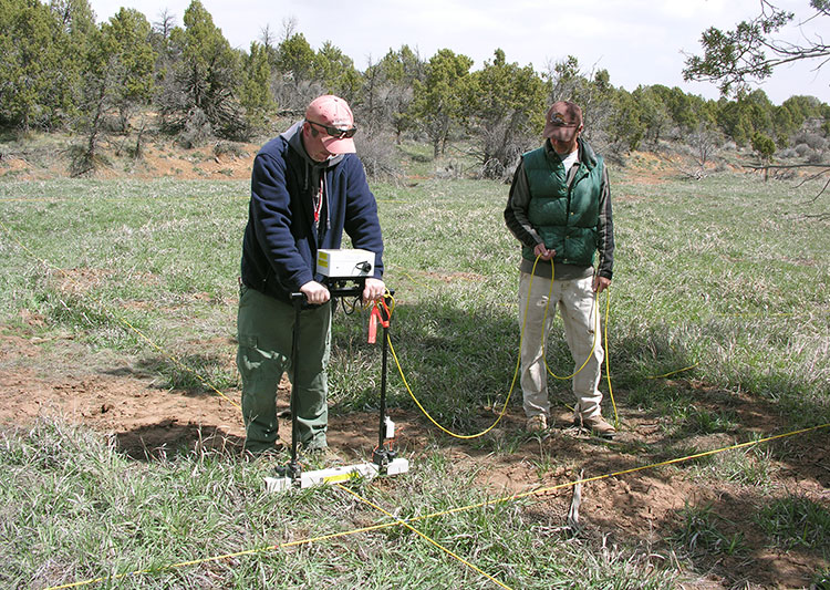
Not all hidden empires lie under jungle. Some are beneath our feet in city parks and farm fields. Ground-penetrating radar (GPR) sends electromagnetic waves into the soil; different materials reflect those waves differently. A stone wall or a void (like a tomb) shows up as a distinct signal. Coupled with magnetometry, which detects subtle variations in soil magnetism caused by ancient burning or digging, these tools allow archaeologists to create “x-ray” maps of buried settlements before excavation. Whole Roman forums, Viking halls, and Egyptian tomb complexes have been mapped this way, often leading to targeted digs that minimize damage.
Satellite Imagery and Multispectral Scanning
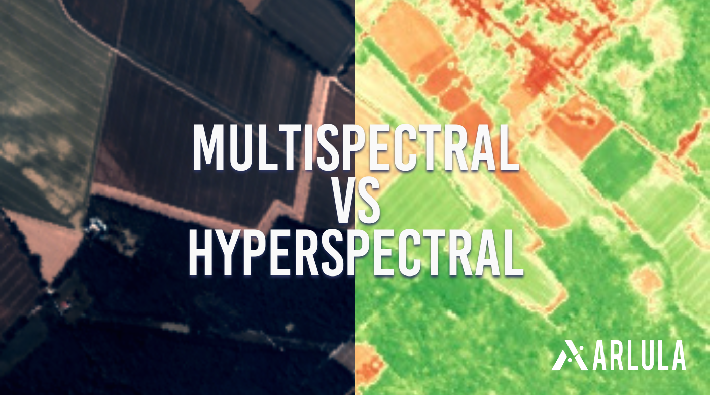
It turns out that buried ruins leave chemical footprints on the soil that affect how crops grow or how the ground retains moisture. Satellite images in near-infrared or thermal bands can reveal those phantom structures. Sarah Parcak, a pioneer in “space archaeology,” has identified thousands of potential sites in Egypt alone by looking at satellite data—tombs, pyramids, and even unknown cities under the sand.
Ancient DNA and Isotope Analysis
Sometimes the most profound hidden empires aren’t visible in stone; they live on in our bones. The study of ancient DNA extracted from skeletons can map migrations, reveal family structures, and uncover the mixing of populations that texts never recorded. We now know that the people who built Stonehenge were largely replaced by a wave of newcomers from continental Europe; that the Indus Valley civilization was genetically diverse; and that Plague of Justinian victims really did die of Yersinia pestis. This molecular archaeology is opening a new window onto lost civilizations that left few written records.
The impact? We’re not just finding stuff—we’re understanding how hidden empires rose, functioned, and ultimately collapsed.
Case Studies of Hidden Empires Rediscovered
Let’s travel the world and touch the stones of empires that, until recently, were little more than legend or footnote.
The Maya Megalopolis: More People Than We Dreamed
For decades, the Classic Maya (c. 250–900 CE) were pictured as a collection of relatively modest city-states dotted through the rainforest, with small populations sustained by slash-and-burn farming. Then came LiDAR. In 2018, a groundbreaking survey over 2,100 square kilometers of northern Guatemala’s Petén region peeled back the canopy to expose an astonishing 60,000 previously unknown structures: houses, palaces, elevated highways, and extensive fortifications. The hidden empire that lay beneath was a continuous urban web, with cities like Tikal, Holmul, and El Zotz linked by raised causeways quarried stone by stone.
This wasn’t a sparsely populated wilderness. Archaeologists now estimate the Maya lowlands may have supported 10–15 million people at their peak—comparable to ancient China’s densest regions. The Maya engineered vast irrigation systems, terraced hillsides, and wetland farms that produced surplus on an industrial scale. That army of mouths also explains the intensity of warfare and the eventual strain on resources when prolonged drought struck in the 9th century. LiDAR didn’t just find hidden buildings; it reframed an entire ancient civilization, transforming it from a mysterious collection of ruins into a thoroughly complex, populous, and interconnected world.
Angkor’s Vast Water Empire
Angkor Wat, the temple beloved of tourists, was once the spiritual heart of the Khmer Empire (9th–15th centuries). But until the 21st century, we didn’t grasp the sheer scale of that hidden empire. Using radar and LiDAR, archaeologists discovered that the temple complex was merely the center of a sprawling urban grid covering over 1,000 square kilometers—by some measures, the largest pre-industrial city on earth.
The real revelation was the water management system. Angkor was laced with canals, reservoirs (barays), and embankments that captured the monsoon rains and redistributed them through a network so complex it would make a Dutch engineer weep with envy. This hydraulic civilization sustained a population of nearly a million, allowing three rice crops a year. But the same system that made it great may have destroyed it: alterations to the water flow, combined with extreme climate variability, likely triggered catastrophic failures—floods and drought in quick succession. The city slowly emptied, and the jungle swallowed its outskirts. Modern archaeology has turned Angkor from a temple-island into a lesson in the delicate balance between human ambition and the environment.
The Hittites: From Bible Footnote to Empire
For centuries, the Hittites were known only as a mysterious people mentioned in the Old Testament. Then, in the 19th century, the ruins of Hattusa, their capital in central Anatolia, were discovered. But it’s the modern surveys that have truly revealed the extent of their hidden empire. Through magnetometry and careful excavation, archaeologists have mapped a city of 165 hectares, with monumental gates, royal residences, and the famous library that yielded thousands of clay tablets—diplomatic correspondence, legal codes, and ritual texts.
The Hittites were masters of chariot warfare and metalworking, but their empire (c. 1600–1178 BCE) wasn’t a monolithic state; it was a confederation of vassal kingdoms held together by marriage alliances and military might. Satellite imagery has helped identify dozens of previously unknown Hittite sites, from fortresses to grain storage facilities. We now understand them not as a footnote but as one of the great powers of the Bronze Age, alongside Egypt, Babylon, and Assyria. Their sudden collapse around 1178 BCE, part of the larger Late Bronze Age Collapse, remains a riveting cold case—likely a combo of climate shifts, invasion, and internal strife.
The Indus Valley: A Civilization Without War?
When the first cities of the Indus Valley (c. 2600–1900 BCE) were excavated in the 1920s, they stunned the world: Harappa and Mohenjo-Daro boasted grid-pattern streets, advanced drainage, and standardized fired bricks. It was clearly a sophisticated ancient civilization, but we’ve only recently started to grasp its true expanse. A combination of satellite imagery and ground surveys has identified over 1,000 Indus settlements scattered across modern Pakistan and northwest India, from the Himalayan foothills to the Arabian Sea.
One of the most tantalizing aspects of this hidden empire is the apparent lack of warfare. Unlike its Mesopotamian contemporaries, the Indus Valley left no triumphal art of kings smiting enemies, no large caches of weapons, and their cities lack monumental defensive works—though they did have gates and watchtowers. They were obsessive traders, with seals found as far as Central Asia, and their writing (still undeciphered) hints at a deeply religious or mercantile culture. Then, around 1900 BCE, the cities were abandoned. Recent isotope analysis of lake sediments suggests a long, gradual drying of the climate that would have made farming nonviable. The Indus people didn’t vanish; they simply moved, merging into other populations and taking their genes and perhaps their stories with them.
Göbekli Tepe: The Temple That Rewrote Prehistory
No roundup of hidden empires would be complete without mentioning the site that pushed monumental architecture back by 6,000 years. Göbekli Tepe, in southeastern Turkey, was deliberately buried around 8000 BCE, which is why it survived unnoticed for millennia. When Klaus Schmidt first dug there in the mid-1990s, he found T-shaped limestone pillars carved with foxes, scorpions, and vultures, arranged in circles. This wasn’t a city; it was a ritual complex built by hunter-gatherers who had not yet invented pottery, agriculture, or permanent villages.
Ground-penetrating radar has since revealed more than a dozen similar enclosures still buried, suggesting a vast ceremonial landscape. The conventional story used to be that agriculture led to settled life, which then allowed for religion and complex society. Göbekli Tepe suggests the opposite: perhaps the need to build these temples brought people together, sparking the very domestication of plants and animals. It’s a hidden empire of the mind—a belief system so powerful it reorganized humanity.
The Nabataeans: Masters of the Desert
The Nabataeans, who built the rock-cut city of Petra in modern Jordan, are remembered for that iconic Treasury facade. But recent archaeological discoveries have exposed an empire of hydraulic engineering. Using satellite imagery, surveys have identified hundreds of kilometers of aqueducts, cisterns, and terraces that once supported a thriving city of 30,000 in one of the driest places on earth. The Nabataeans controlled the incense trade routes, amassing wealth and building a kingdom that stretched from Damascus to the Red Sea. Their ability to harvest every drop of rainwater—channeling flash floods into underground cisterns—allowed them to create a green oasis in the desert. When Rome eventually annexed their kingdom, much of their engineering knowledge was lost or dismissed as local cleverness, only to be rediscovered now by modern archaeology.
Why Do Civilizations Vanish?
As we peel back the layers of these hidden empires, a humbling pattern emerges: no matter how mighty, every civilization can fail. The research tools of modern archaeology don’t just find cities; they diagnose causes of collapse.
- Climate change played a role for the Maya, the Indus, the Old Kingdom of Egypt, and possibly Angkor. Tree-ring data, lake sediments, and speleothems reveal prolonged droughts that would have crippled food production.
- Environmental degradation is another common thread: deforestation, soil exhaustion, and over-irrigation led to salinization. The Maya, for instance, may have cut down too many trees, altering local rainfall patterns.
- War and social upheaval shattered the Hittites and the Mycenaeans. Sometimes external enemies were the trigger; sometimes internal rebellion.
- Disease may have swept through dense populations with no immunity, as in the case of the Justinianic plague or the Columbian Exchange that decimated the Americas.
But here’s the twist: civilizations rarely vanish completely. Their people scatter, merge with neighbors, and pass on genes, technologies, and stories. The “lost” Maya survive today in millions of Maya-speaking people; the “disappeared” Indus folk are part of the genetic tapestry of South Asia. Hidden empires aren’t really lost—they’re just forgotten by mainstream history until we dig them up again.
The Future of Discovery
If the last decade has taught us anything, it’s that we’ve barely scratched the surface. Lidar-equipped drones are now so affordable that citizen scientists are scanning hillsides in their spare time. Machine learning algorithms are being trained to spot telltale patterns in satellite imagery that the human eye would miss. And underwater archaeology, using sonar and autonomous submersibles, is beginning to explore the continental shelves drowned by rising seas after the last ice age. Off the coast of India, the submerged city of Dwarka has yielded stone structures; in the North Sea, the drowned landscape of Doggerland is giving up tools and bones from the Mesolithic hunters who once roamed there.
The Sahara, too, holds secrets: when radar satellites look beneath the sand, they see dried riverbeds that once sustained Neolithic communities. Imagine entire hidden empires still sleeping under the desert, waiting for the right technology to shine a light on them. The next generation of archaeologists may uncover a Pleistocene civilization we never imagined, or finally locate the capital of the elusive Kingdom of Kush in Sudan.
We are, without doubt, living in the greatest age of archaeological discoveries. More sites have been found in the past twenty years than in the previous two hundred. And each new discovery doesn’t just add a pin to a map; it forces us to redraw the whole map, to question assumptions about human capability, resilience, and fragility.
—
As I write this, somewhere a drone is buzzing over an uncharted plateau in the Amazon rainforest, its LiDAR sensor painting a ghostly image of circular earthworks that might be the next big headline. Perhaps it’s another hidden empire that will change how we see history.
If you’re as captivated as I am by these stories—by the rise and fall of forgotten kingdoms, the thrill of technology peeling back the veil of time—then I’d like to invite you to go deeper. Explore the secrets of hidden empires with our interactive timeline. Journey from Göbekli Tepe to Angkor Wat, zoom through millennia, and watch as modern archaeology reveals civilizations layer by layer. It’s the perfect way to satisfy your inner historian and see for yourself how the past isn’t as distant as you think.